
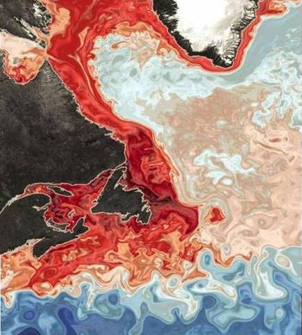
The intersections of global climate change impacts in Svalbard Archipelago and the St. Lawrence Seaway are tangibly linked by the northward flow of the increasingly warming Florida/Atlantic Gulf Stream. On its northward journey, it meets up with the cooler surface of the Labrador Current just southeast of Newfoundland. Research by Washington University reported in the Telegram (09/2018) shows the above computer model where the red area indicates the higher oxygen levels of the cooler surface water of the Labrador Current. The warmer deeper, and less oxygenized water of the Florida Gulf Stream is flowing into the St. Lawrence Seaway impacting its ecology.
It is within this philosophical and scientific framework of the interdependence of all things that my aesthetic research based practice investigates issues of climate change impacts on shoreline and place identity. My aesthetic strategy is to reinvent out-dated narratives of nautical sailing maps/charts of the St. Lawrence Seaway and Great Lake within a contemporary discussion on climate change. I do this using painting motifs and chronological juxtapositions of overlapping chart shoreline elements.
Geographies in transition is not unique to the contemporary rapid climate change impacts being recorded. I find inspiration from the geological origins of earth\’s structures such as the unusual Svalbard mountains, currently being revealed as a former tropic, by the melting of glaciers. Similarly, I can make aesthetic connections knowing that during the Pleistocene Epoch (about 2,600,000 to 11,700 years ago), glaciers occupied the deep depression in the earth where the St. Lawrence River is today. The Champlain Sea, flooded this depression, replacing the glaciers, from about 13,000 to 9,500 years ago. A subsequent slight uplifting of the continent was enough to expel this arm of the ocean, and about 6,000 years ago a residual riverlike watercourse—the St. Lawrence—was established. (source: Britannica) However, as can be seen by these geological dates, changes took many thousands of years, and were not characteristic of the rapidity of changes being scientifically recorded going back to the 1970’s.
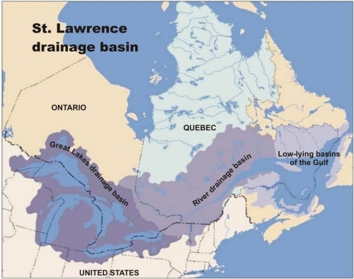
The information I’m sharing in this blog is just the tip of the “iceberg” so to speak, of the enormous amount of background research that my art project involves. My purpose is to authentically visually communicate the scientific data that can be overwhelming for some. The St. Lawrence River significance includes as a global fresh water and transit corridor to inland North America, but also subliminally in the Canadian psyche.